FarSounder: Crowdsourcing the Ocean’s Depths

We all know that there has been a noticeable rise in explorer yachts. As both owners and charter guests seek increasingly bespoke yachting experiences in remote and exotic locations, yachts are increasingly required to navigate waters that are frequently poorly charted or in some cases, completely uncharted.
But you may be surprised to learn that it’s not only those remote waters where we have little or no data.
According to Seabed 2030 - a global initiative seeking to map the world’s oceans by 2030 - we know the Moon and Mars’ topography better than we know our own planet. Indeed, less than 30% of the world’s ocean floor is mapped. FarSounder is helping to change that.
FarSounder’s advanced Argos 3D Forward-Looking Sonars facilitate safe navigation powered by unique real-time environmental awareness, for private yachts, cruise ships, research vessels, and government fleets around the world.
This world fleet is now at the heart of FarSounder’s Data Sharing Program, an exciting initiative that for the first time, allows mariners to both contribute to and access shared bathymetry data. Collected by Argos systems across the FarSounder user fleet, this shared data is actively helping vessels undertake safer voyages in uncharted, poorly charted, or hazard-prone waters. We spoke with FarSounder’s senior application engineer, Heath Henley, to find out more about how FarSounder’s systems are making the ocean safer for everyone, in real time.
Navigating uncharted waters
FarSounder’s Argos systems provide vessels with crucial navigation support, especially in areas in which official Electronic Nautical Charts (ENCs) are outdated, incomplete, or non-existent. In the US, about half the coastal and great lakes waters remain uncharted, and global and territorial waters of other countries the situation is often worse. For these vessels, having up-to-date depth information can mean the difference between a safe voyage and a dangerous, potentially life-threatening collision.

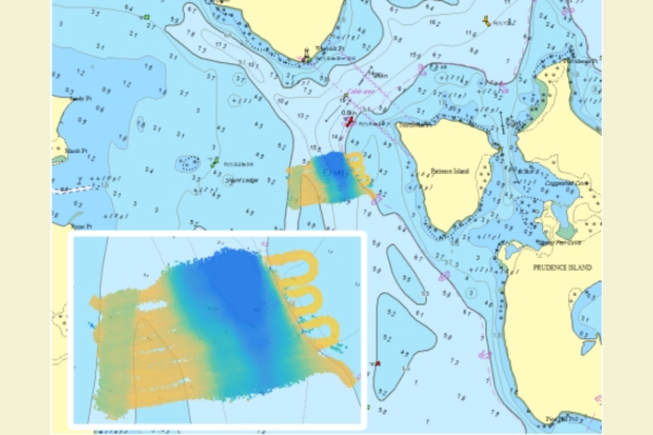
The value of the Argos sonar system extends far beyond real-time navigation. Traditionally, sonar systems were only used to inform the ship’s immediate course. However, with FarSounder’s Local History Mapping feature, vessels equipped with Argos sonars have the option to generate and locally store seafloor maps as they travel. This real-time mapping capability allows mariners to create and save detailed representations of the seafloor, which can be referenced during future voyages.
Safer repeat voyages and better anchoring
Local History Mapping is especially beneficial for vessels making multiple visits to the same area. “For instance, when anchoring in a new location, a vessel can perform a quick, informal survey of the surrounding seafloor. If currents or tides cause the vessel to rotate or drift slightly, the Local History Mapping retains the recorded depth data, ensuring that mariners still have an accurate understanding of the surrounding seabed. This makes the anchoring process more reliable and improves situational awareness,” Heath explained.
Another use case of Local History Mapping occurs when vessels must navigate narrow channels, coves, or other constrained waterways. When leaving an anchorage, especially at night, mariners can follow their previous track through an area using the stored seafloor data as a reliable guide, allowing vessels to safely navigate with confidence.
Crowdsourced bathymetry: A global network
In recent years, FarSounder has expanded the value of its Argos systems through the introduction of its Data Sharing Program. “This program allows participating users to anonymously share their collected depth data with other vessels using the Argos system. In return, these users gain access to aggregated and anonymised depth data from others who have sailed in the same waters,” said Heath.
This crowdsourced bathymetry system is particularly useful for vessels navigating unfamiliar areas. Instead of relying solely on their own sonar data, mariners can access a wealth of collective knowledge built from the contributions of other Argos-equipped vessels. This collaborative approach enhances navigational safety and confidence, especially in regions that are poorly charted or subject to dynamic seafloor conditions.
Improving the world’s charts
The need for FarSounder’s Data Sharing Program is clear. “In well-charted areas, passengers aboard expedition vessels might assume that everything one needs to know about navigating a given area already exists on nautical charts. However, they would be mistaken,” wrote Co-Founder and CEO Matthew Zimmerman in a recent article. “Though the US has some of the best charts in the world, about half of the depth information found on NOAA charts is based on hydrographic surveys conducted before 1940. In many cases, the data is more than 150 years old and, in some cases, the depth measurements are so old that they may legitimately have originated from Captain Cook in 1778.”

Accordingly, FarSounder’s Data Sharing Program contributes anonymised depth data to the International Hydrographic Organization’s (IHO) Crowdsourced Bathymetry (CSB) database, hosted at NOAA’s Data Centre for Digital Bathymetry. This global initiative aims to improve the world’s nautical charts by collecting crowdsourced depth data from vessels around the world.
FarSounder has been an active participant in the IHO’s Crowdsourced Bathymetry Working Group since 2017 and has become what is called a Trusted Node, enabling Argos system users to easily contribute valuable data to the global mapping effort.
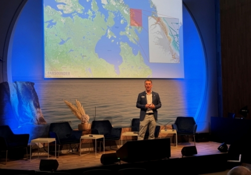
“One notable example of the impact of this program is the Canadian Hydrographic Service’s use of CSB data, including contributions from FarSounder users, to update chart CHS 7053 which spans Padloping Island to Clyde Inlet,” Heath commented. “This demonstrates the tangible benefits of crowdsourced bathymetry in improving navigational safety for the broader maritime community.”
A simple, transparent system for data sharing
Participation in FarSounder’s Data Sharing Program is entirely voluntary. Users who choose not to contribute can still access the aggregated data through a subscription-based model. Those who do participate, however, enjoy the added benefit of free access to the aggregated data from all participating vessels.
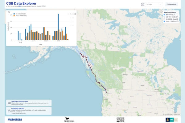
To make the process simple and transparent, FarSounder has developed an intuitive dashboard where users can view their contributions to the IHO Crowdsourced Bathymetry database and Seabed 2030, a global project aiming to map the entirety of the world’s oceans by 2030. The dashboard also highlights the most active contributors, allowing users to see the real-world impact of their data sharing. For example, a top contributor in the Pacific Northwest has shared significant depth data that is now accessible to the global maritime community.
Looking forward to an expanding data horizon
While the primary focus of the Data Sharing Program is depth data, FarSounder is already looking to the future with plans to expand the types of data that can be collected and shared.
“We aim to enable users to report additional observations, such as sightings of whales, containers, and even marine debris,” Heath noted. “This enhanced capability will allow the maritime community to not only navigate more safely but also contribute to global environmental monitoring efforts. The data they collect can be shared with organisations that are interested in studying or addressing these maritime challenges, which we expect to further broaden the positive impact of FarSounder’s technology.”
Setting the standard in maritime safety
Data gathered from FarSounder’s Argos user network is a valuable part of the global effort to map the seafloor. What started as a system for collecting data via external hard drives, physically shipped back and forth, has evolved into a sophisticated cloud-based network that enables seamless data sharing across the fleet. It’s an impressive achievement that FarSounder, a technology company based in Rhode Island in the US, is rightfully proud of.
FarSounder’s range of Argos Navigation Sonars is trusted by seafarers around the world to safely take them into uncharted waters. As the only products on the market capable of a true, 3-dimensional image of the water column ahead of a vessel in real-time at distances of up to 1,000 metres, Argos delivers the next level in safe and confident navigation.
Contact FarSounder for more information.


Post your comment
You cannot post comments until you have logged in.
Login to post a commentComments
No one has commented on this page yet.
RSS feed for comments on this page | RSS feed for all comments